Caldera Blanca
Caldera Blanca
A volcanic crater nearly a kilometer in diameter, Caldera Blanca is explored on foot from Mancha Blanca. Free access, 3 to 4 hours of hiking through lava and white ash landscape in the heart of Lanzarote.
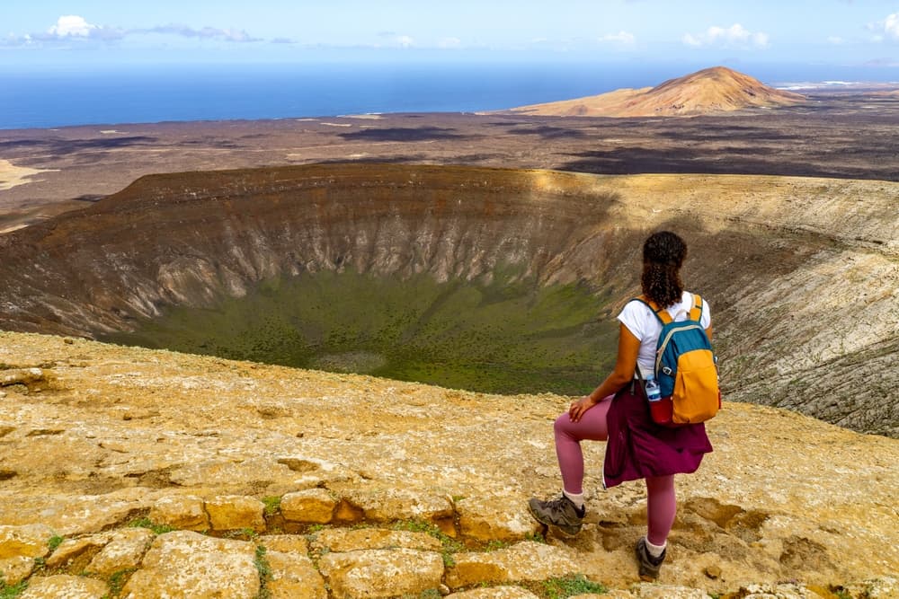
Caldera Blanca is an extinct volcano located in the heart of Timanfaya National Park on Lanzarote. Its crater, nearly a kilometer in diameter, dominates a landscape of black lava and volcanic ash. The hike circling it offers complete immersion in the raw geology of the Canaries, far from the crowds gathered along the park's main road.
Quick reference
- Access: departure from Mancha Blanca parking, on the LZ-56 — free vehicle access
- Entry: free (outside Timanfaya's paid perimeter)
- Recommended duration: 3 to 4 hours for the complete loop
- Difficulty: moderate — uneven volcanic terrain, elevation gain of approximately 300 m
- What to wear: hiking boots essential, hat and plenty of water
- Accessibility: not wheelchair accessible — unmarked trail on volcanic terrain
What you'll see
The trail follows fields of solidified lava (malpais), secondary volcanic cones and rope lava formations. Reaching the crater's edge, the view drops onto a white ash floor — hence the name — contrasting sharply with the black walls. On clear days, the view extends to the ocean and neighboring Fuerteventura.
History and context
Caldera Blanca is one of Lanzarote's largest volcanic craters. It formed during eruptions far earlier than the great lava flows of 1730-1736 that covered a third of the island. These 18th-century eruptions created Timanfaya's lunar landscape, designated a national park in 1974. The Caldera Blanca area, though bordering the park, remains freely accessible and represents one of the few places where you can hike freely in this volcanic environment.
Highlights of the visit
The crater's edge
The circuit's high point, at approximately 458 m elevation, reveals the crater's full measure. The interior walls drop sheer onto the ash-covered floor. Silence and the absence of vegetation heighten the impression of a landscape outside time.
The malpais of Corona
On the return path, the trail crosses expanses of aa and pahoehoe lava. These two lava types, with radically different textures, concretely illustrate the diversity of volcanic eruptions. A few pioneer lichens colonize the fissures — the only signs of plant life.
Views over Timanfaya
From the heights, the red and black cones of Montañas del Fuego stand out on the horizon. This panorama conveys the scale of historical eruptions and the radical transformation of the territory.
Photography tips
Morning light is ideal: it accentuates contrast between the white ash and black lava. Late afternoon brings ochre and red tones to the crater walls. Avoid midday hours — the light is harsh and the ground reflects intensely. No photography restrictions on this site.
Location and access
Caldera Blanca lies in the municipality of Tinajo, on Lanzarote's west side. The trail departure is signposted from Mancha Blanca village, on the LZ-56 road. No regular public transport serves this starting point — a rental vehicle is necessary. Parking is free and unattended. The site falls outside the paid perimeter of Timanfaya National Park; the main entrance is a few kilometers south.
Nearby attractions
- Timanfaya National Park — Montañas del Fuego and the volcano route, accessible by guided bus from the main entrance.
- Jameos del Agua — lava tunnel designed by César Manrique, featuring an underground lake and endemic wildlife.
- Cueva de los Verdes — underground volcanic gallery among Europe's longest.
- El Golfo — emerald green lagoon nestled in a half-submerged crater on the west coast.
Frequently asked questions
No. Caldera Blanca lies outside Timanfaya National Park's paid perimeter. Trail and parking access are entirely free.
Autumn and spring offer the most pleasant temperatures. In summer, heat and sand wind can make hiking arduous. Start early regardless of season.
Yes, both sites are close. Hike Caldera Blanca in the morning, then head to Timanfaya's main entrance in the afternoon for the volcano route guided bus tour.
The trail is partially marked by cairns and ground marks. Bring a map or download the GPS track before setting out — uniform volcanic terrain can be disorienting.
Plan for at least 2 liters per person. There are no water sources or facilities along the route. The terrain reflects heat and dehydration occurs quickly.
The circuit suits children accustomed to hiking and capable of 3 to 4 hours on uneven terrain. Not recommended for very young children due to elevation gain and lack of shade.
Interested in this visit?
We can include it in your personalised itinerary.