El Hierro
The westernmost of the Canaries, a Biosphere Reserve since 2000, energy-independent on certain days thanks to Gorona del Viento. An island for hikers and divers.
El Hierro is the westernmost and smallest of the seven inhabited islands in the archipelago: 269 km² with some 11,000 inhabitants, half of whom live in Valverde, the capital perched at 600 metres altitude and the only island capital in the Canaries not situated on the coast. Until the Greenwich Meridian reform in 1884, Cape Orchilla at the western tip of the island marked the zero meridian for European cartographers. This position as a finisterre long isolated El Hierro, which partly explains why we find today a preserved territory, classified as a UNESCO Biosphere Reserve since 2000 and a Global Geopark since 2014.
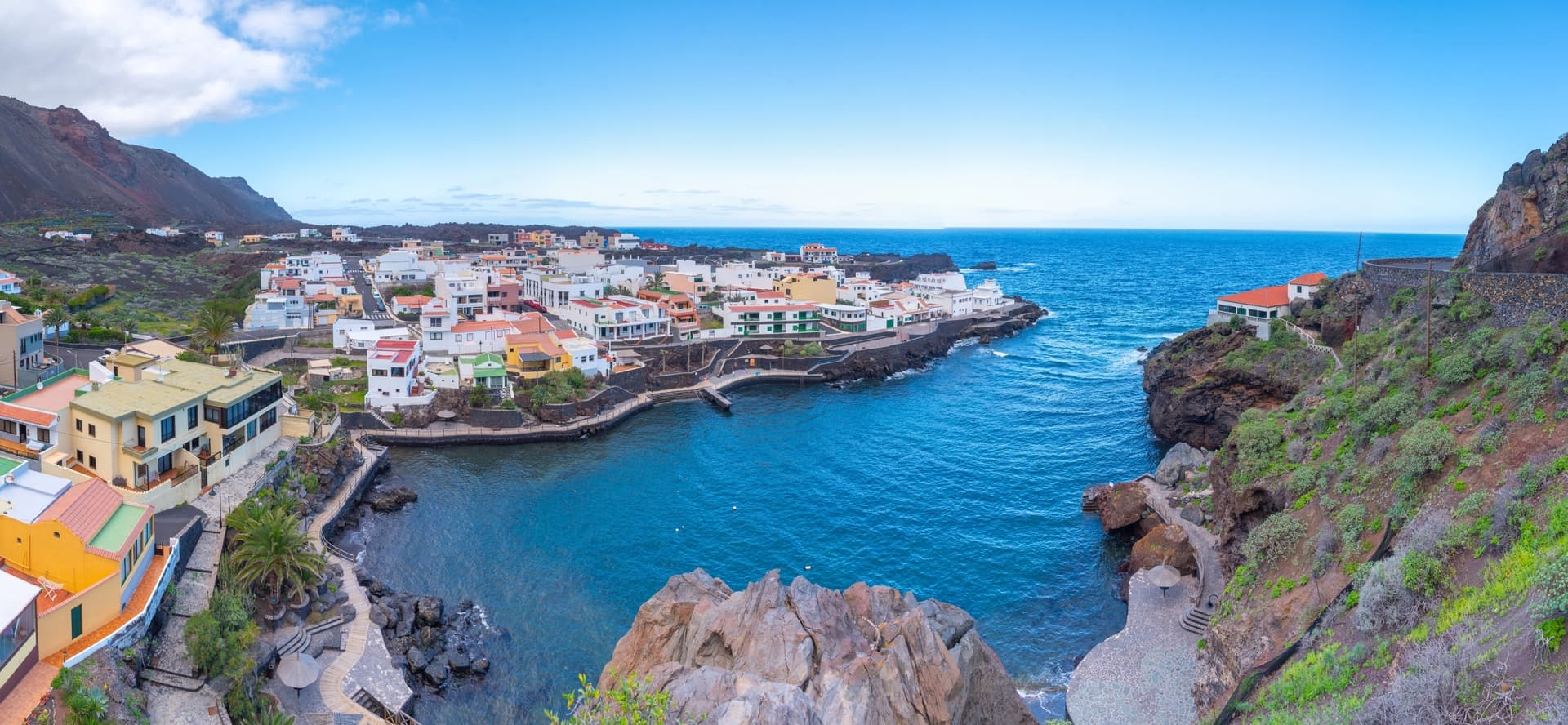
The island is shaped like a horseshoe open towards the north-west, a remnant of a gigantic landslide that occurred 50,000 years ago which tilted a third of the volcanic edifice into the ocean. This rugged relief produces striking contrasts over very short distances: in 30 minutes' drive from Valverde, we pass from the damp meadows of Nisdafe, where cattle graze under perpetual drizzle, to the black lava flows of El Julan on the southern coast, exposed to full sun. The highest point, Pico de Malpaso, reaches 1,501 metres. The sabinar of La Dehesa, a forest of junipers twisted by the trade winds, has become the island's emblematic image: centenarian trees laid horizontal by the force of the wind.
El Hierro is also an energy laboratory observed worldwide. The hybrid Gorona del Viento power station, inaugurated in 2014, combines five wind turbines above Valverde and a pumped-storage hydroelectricity system between two reservoirs situated 700 metres apart in elevation. The system covers 100% of the island's electricity consumption on certain days. The economic engine remains, however, agriculture: Frontera wines planted in individual craters protected from the winds, tropical pineapples in La Frontera, prickly pears, and a goat's cheese, queso herreño, smoked with fig wood and heather, which obtained its PDO in 2014.
Local culture is marked by the Bajada de la Virgen de los Reyes, a pilgrimage that takes place only every four years (next edition in 2025). For three days, the statue of the patroness descends from her sanctuary in La Dehesa to Valverde over 28 kilometres, accompanied by the bailarinas and traditional dances. For the rest of the year, the island moves at a leisurely pace around a few villages: El Pinar with its wheel-less pottery craftsmanship, inherited from the pre-Hispanic Bimbaches, Sabinosa and its thermal hamlet of Pozo de la Salud, La Restinga to the south, a fishing port converted into a diving village since the 1990s.
It is precisely at La Restinga that the Reserva Marina del Mar de las Calmas is found, created in 1996, in an area sheltered from dominant swells. Visibility regularly exceeds 30 metres and the basalt seabeds attract dusky groupers, barracudas, stingrays and schools of bonito. The underwater eruption of Tagoro in 2011, one kilometre off La Restinga, reshaped part of these seabeds and created a new volcanic cone at 88 metres depth, now colonised by specific marine life that scientists continue to study.
El Hierro is not a beach destination: the coast is essentially made up of cliffs and natural pools carved from lava, like those of Charco Azul or La Maceta on the northern coast. It is an island for those seeking calm, hiking, diving and a certain relationship with time. Our team recommends it to those who have already visited other islands in the archipelago and want to see a less frequented side of it: fewer than 25,000 visitors a year, the equivalent of what Tenerife receives in a single day.
What to discover
Mirador de la Peña. A viewpoint designed by César Manrique on the northern cliff, 700 metres above El Hierro's gulf. On clear days, La Palma and La Gomera can be seen from the restaurant terrace.
Diving at La Restinga. The Reserva Marina del Mar de las Calmas offers an average of 30 metres visibility and sites accessible from 12 metres such as El Bajón, a former underwater volcano covered in groupers.
Sabinar de La Dehesa. Forest of junipers laid horizontal by the trade winds, an hour's drive from Sabinosa. The site can be visited on foot along a marked trail of about one hour.
Camino de la Virgen. A 28 km pilgrimage trail crossing the island from the sanctuary of La Dehesa to Valverde, with 1,200 metres of positive elevation gain. Allow two days for leisurely hiking.
Charco Azul and La Maceta. Natural pools set within the lava flows of the northern coast, sheltered swimming from the swell between April and October.
When to go
El Hierro's climate is more humid and temperate than that of the eastern islands. Temperatures remain between 18°C in winter and 26°C in summer in Valverde, but easily climb to 30°C on the southern coast of Mar de las Calmas, sheltered from the trade winds. The best period to combine hiking and diving runs from May to September: water temperatures reach 23-24°C in August-September, ideal for diving without thick suits. The months of April, May and October offer the best balance for hiking, with fewer tourists and mild temperatures on high-altitude trails.
From December to February, the northern part of the island receives notable precipitation (sometimes 80 to 100 mm per month on the Nisdafe plateau) and fog regularly covers the heights. This does not hinder diving in the south, where the microclimate remains dry, but it can limit northern viewpoints like the Mirador de la Peña. The months of July and August remain sparsely visited compared to other islands, but it is high season for Canarians who come as families to La Restinga.
Practical advice
We recommend a minimum of 3 full days on the island, ideally 4 to 5 to combine hiking, diving and exploration of the hamlets. Access is either by internal flight from Tenerife North (35 minutes, several daily connections by Binter Canarias) or by ferry from Los Cristianos on Tenerife (2h30, one to two crossings per day). Car rental is essential: the island has only one main road, the HI-1, and distances appear short but winding roads double announced travel times. Valverde to La Restinga represents 45 minutes actual driving.
El Hierro naturally combines with La Gomera and La Palma for a circuit dedicated to the western islands and hiking, rather than with the more arid eastern islands. Accommodation remains modest: renovated rural houses in the villages, a few small family hotels in Valverde and Frontera, no beach resorts. Our team points El Hierro toward contemplative travellers, hikers, divers and those who have already explored Tenerife or Gran Canaria and are looking for a more rural dimension. Conversely, it is an island not well suited to families with very young children seeking sandy beaches.